Morphometric classification, evolution, and distribution of volcanic edifices in the Philippines
Paguican EMR, Grosse P, Fabbro GN, Kervyn M
How to cite: Paguican, E. M. R., Grosse, P., Fabbro, G. N., and Kervyn, M.: Morphometric classification, evolution, and distribution of volcanic edifices in the Philippines, EGU General Assembly 2021, online, 19–30 Apr 2021, EGU21-9026, https://doi.org/10.5194/egusphere-egu21-9026, 2021.
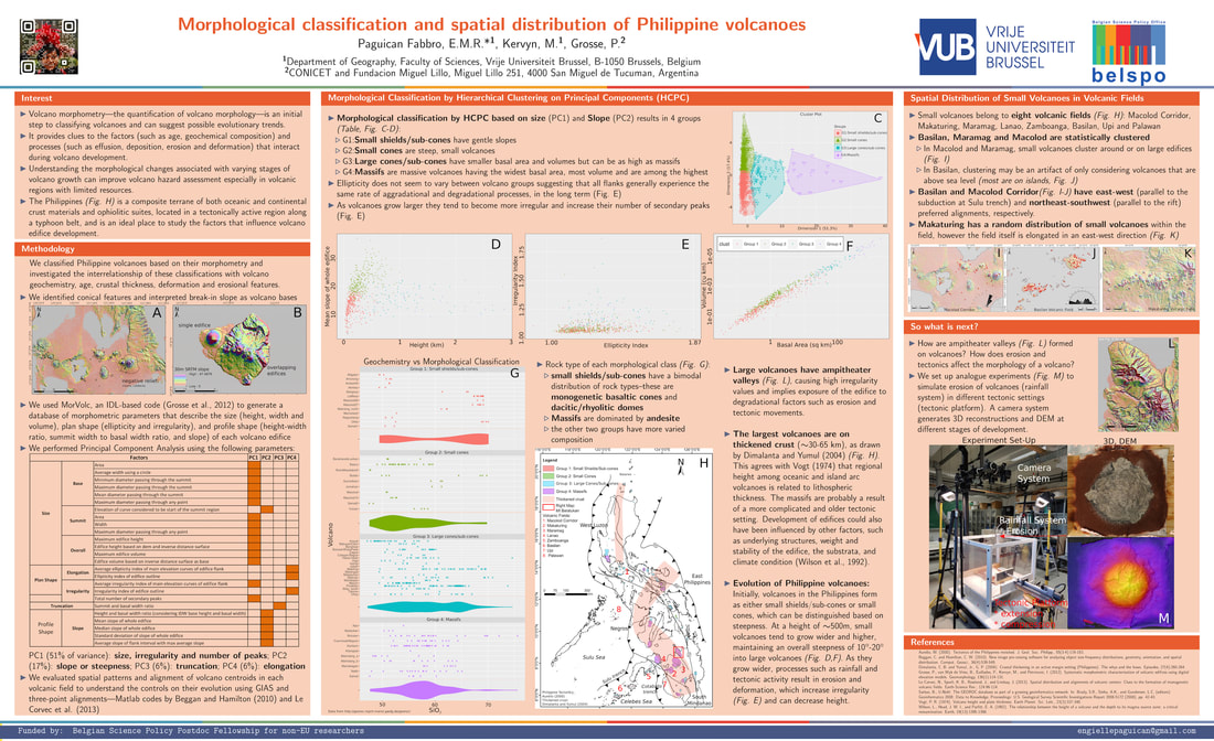
Volcano morphometry provides evidence for the magmatic and tectonic factors that control the growth of edifices and their spatial distribution in volcanic fields. We identified 731 volcanic edifices in the Philippine island arc using SRTM 30 m digital elevation models, and quantitatively described their morphology using the MORVOLC algorithm and their spatial distribution using Matlab GIAS and three-point analysis codes. A hierarchical classification by principal component analysis (HCPC) was used to morphometrically classify the edifices into four classes, which we interpret as small flat cones, small steep cones, large cones, and massifs. This classification is mainly based on edifice size and irregularity (PC1) and steepness (mean slope and height/basal width ratio; PC2), and to a lesser extent on the size of the summit region and edifice truncation (PC3), and edifice elongation (PC4). Both small flat cones and small steep cones have volumes of <10 km3 with means of <1 km3. The small flat cones have mean slopes of <21° (mean = 13°), whereas the small steep cones have mean slopes of 14–37° (mean = 22°). The large cones have volumes mostly between 1 and 200 km3 (mean = 29 km3), whereas massifs have larger volumes: between 76 and 675 km3 (mean = 267 km3). Both classes have similar mean slopes with overall means of 15°.
The morphometric classification, complemented by previously published geochemical data from some edifices, indicates continuous variation between volcano classes, which represent stages along an evolutionary trend. The small flat cones are mostly monogenetic, whereas the small steep cones represent an early growth stage of stratovolcanoes. Some small cones develop into large polygenetic cones, and these can grow laterally into massifs. Both large cones and massifs are mostly found on thickened crust. There is a trend towards more silicic compositions from small to large cones, perhaps due to larger edifice loads preventing mafic dykes from reaching the surface, that in turn drives magmatic evolution. More evolved and explosive magmas cause more silicic volcanoes to be less steep than andesitic volcanoes. The distribution and alignment of smaller edifices within eight volcanic fields shows that the dominant regional or local stress conditions and pre-existing structures influenced magma propagation and their spatial distribution. Associating morphometric classification with the stages of volcano growth will help in the initial assessment of the factors controlling volcano evolution, which might impact our assessment of hazards related to volcanoes.
Quantitative analogue modelling of volcano landscape evolution in response to tectonics and erosion
Paguican EMR, Kervyn M
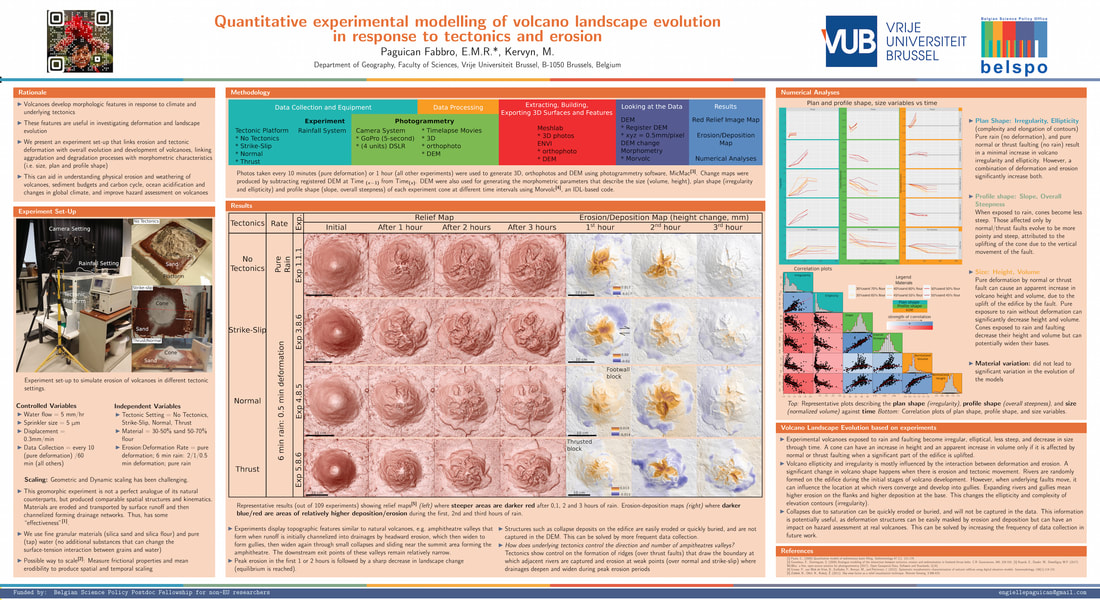
Volcanoes span diverse climate regimes, and underlying tectonics influence their architecture. Tectonically controlled landforms such as volcanoes develop morphologic features that are useful in investigating deformation and landscape evolution. Analogue experiments can help show how edifices are eroded by rainfall and tectonic movement, and the implications for sediment budgets. They are also applicable for understanding the morphological evolution of volcano edifices through time, and the implications for hazard assessment. Identifying morphological features associated with erosion and tectonics is critical for identifying the dominant aggradation and degradation processes.
We present an experimental investigation that links erosion (by rainfall) and deformation (by movement of underlying faults) to the overall evolution and development of volcano edifices. The quantitative evolution of models of four end member tectonic deformation regimes were analyzed: no tectonics, compression, extension, and strike-slip. We systematically varied the ratio of deformation to rainfall, and used different mixtures of silica sand and flour. Our approach combines these analogue models with photogrammetric 3D topography reconstructions. Digital elevation model differencing and morphometric measurements quantify the changes in size, plan and profile shape of edifices and evolution of morphological features. The series of analogue models link surface erosion and deformation features to tectonic and rainfall rates.
Results indicate that volcano erosional valleys form from surface runoffs that develop into drainage systems. They then widen and deepen into gullies, and as more material is removed from the head scarp, they widen to form ampitheatre-shaped valleys that narrow downstream. Morphological features form continuously, but their lifetime is generally short as erosion and sedimentation processes destroy or bury them. Erosion can mask features of deformed edifices that are prone to flank and summit collapse, thus compromising volcano hazard assessments. In tectonically active volcanoes, however, underlying tectonics control the formation of erosional patterns.
Morphological classification and spatial distribution of Philippine volcanoes
Paguican EMR, Kervyn M, Grosse P
The Philippines is an island arc with two major blocks: the aseismic Palawan microcontinental block and the Philippine mobile belt. It is bounded by opposing subduction zones, with the left-lateral Philippine Fault running north-south. This setting is ideal for volcano formation and growth, making it one of the best places to study the controls on island arc volcano morphometry and evolution. In this study, we created a database of volcanic edifices and structures identified on the SRTM digital elevation models (DEM). We generated the morphometry of each edifice using MORVOLC, an IDL code for generating quantitative parameters based on a defined volcano base and DEM. Morphometric results illustrate the large range of size and volume of Philippine volcanoes. Heirarchical classification by principal component analysis suggests that large volcanoes include massifs, large cones and sub-cones distinguished by their volume and basal width, while small edifices consist of small shields and sub-cones, and small cones, distinguished by their slope. Poisson Nearest Neighbor analysis was used to examine the spatial distribution of volcano centroids in each area. Spatial distribution of the different types of volcanoes suggests that large volcanic massifs formed on thickened crust. Although all the volcanic fields and arcs are a response to tectonic activity such as subduction or rifting, only West Luzon, North and South Mindanao, and Eastern Philippines volcanic arcs and Basilan, Macolod, and Maramag volcanic fields present a statistical clustering of volcanic centers. Spatial distribution and preferential alignment of edifices in all volcanic fields confirm that regional structures had some control on their formation. Volcanoes start either as steep cones or as less steep sub-cones and shields. They then grow into large cones, sub-cones and eventually into massifs as focus of eruption shift within the volcano and new eruptive material is deposited on the slopes. Examination of the directions that volcano collapse scars and erosional amphitheater valleys suggests that, during their development, volcano growth is affected by movement on underlying tectonic structures, weight and stability of the growing edifice, structure and composition of the substrata, and intense erosion associated with tropical rainfall.
The Philippines is an island arc with two major blocks: the aseismic Palawan microcontinental block and the Philippine mobile belt. It is bounded by opposing subduction zones, with the left-lateral Philippine Fault running north-south. This setting is ideal for volcano formation and growth, making it one of the best places to study the controls on island arc volcano morphometry and evolution. In this study, we created a database of volcanic edifices and structures identified on the SRTM digital elevation models (DEM). We generated the morphometry of each edifice using MORVOLC, an IDL code for generating quantitative parameters based on a defined volcano base and DEM. Morphometric results illustrate the large range of size and volume of Philippine volcanoes. Heirarchical classification by principal component analysis suggests that large volcanoes include massifs, large cones and sub-cones distinguished by their volume and basal width, while small edifices consist of small shields and sub-cones, and small cones, distinguished by their slope. Poisson Nearest Neighbor analysis was used to examine the spatial distribution of volcano centroids in each area. Spatial distribution of the different types of volcanoes suggests that large volcanic massifs formed on thickened crust. Although all the volcanic fields and arcs are a response to tectonic activity such as subduction or rifting, only West Luzon, North and South Mindanao, and Eastern Philippines volcanic arcs and Basilan, Macolod, and Maramag volcanic fields present a statistical clustering of volcanic centers. Spatial distribution and preferential alignment of edifices in all volcanic fields confirm that regional structures had some control on their formation. Volcanoes start either as steep cones or as less steep sub-cones and shields. They then grow into large cones, sub-cones and eventually into massifs as focus of eruption shift within the volcano and new eruptive material is deposited on the slopes. Examination of the directions that volcano collapse scars and erosional amphitheater valleys suggests that, during their development, volcano growth is affected by movement on underlying tectonic structures, weight and stability of the growing edifice, structure and composition of the substrata, and intense erosion associated with tropical rainfall.
The Grabens, Canyonlands National Park, Utah: evidence for a landslide?
Paguican EMR, Bursik M
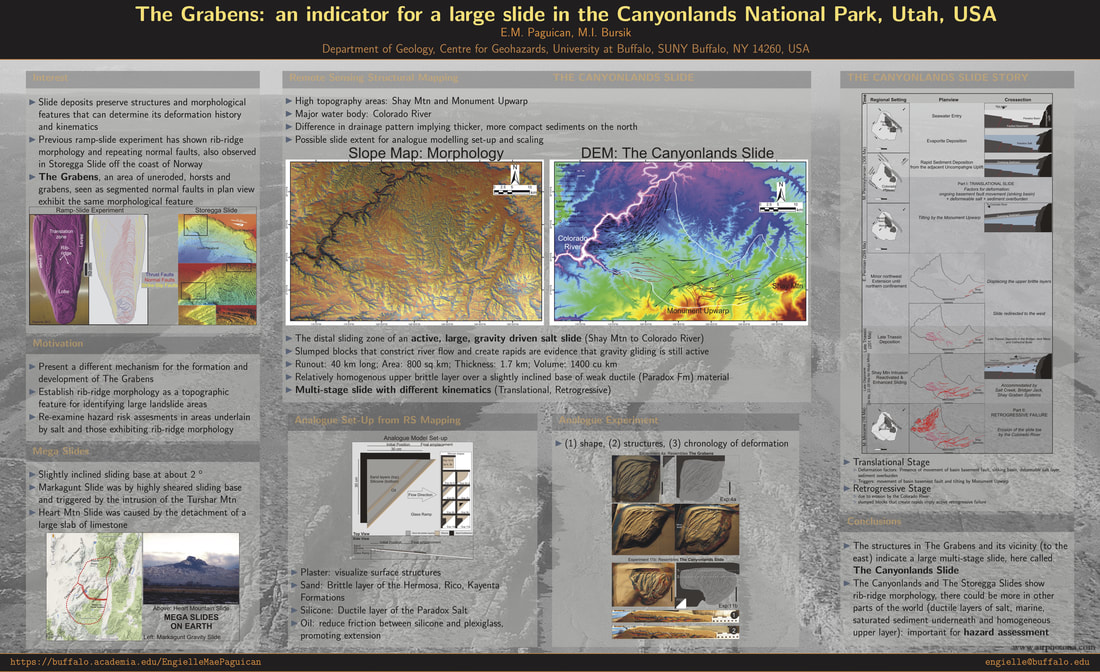
Repeating normal faults that form horsts and grabens, also described as rib-ridge morphology were described in analogue experiments of long runout landslides. The Storegga Slide off the coast of Norway exhibits this morphology. The same feature is also observed in The Grabens, Canyonlands National Park, Utah, an area of arcuate horsts and grabens formed by extending and gliding Pennsylvanian and Permian brittle rocks over the Pennsylvanian Paradox salt, down dip towards the Colorado River. Slumped blocks that constrict river flow and create rapids are evidence that gravity gliding is still active.
Scaled analogue models were constructed with sand and silicon to recreate the extension of the brittle layer over a deforming salt on slightly inclined sliding plane. During the early stages of extension, deformation within the ductile layer resulted in unequal silicon thickness exhibiting spreading and compression areas where deep-seated, major faults that bound the horsts and grabens form. During its development, shallow faults develop in between the major ones.
Based on structural mapping and analogue experiment, we suggest that a large, multi-stage and slow-moving gravity driven slide affects the Canyonlands from the Shay Mountain on the east down west to the Colorado River. The first stage at the end of the Pennsylvanian, was caused by the deformation of the Paradox Salt deposited over active basement faults that accommodated basin sinking, and weight of sediment overburden. The slight tilting to the west by the Monument Upwarp in Early Permian initiated minor extension to the northwest and then to the west due to northern confinement. Intrusion of a magma body that formed the Shay Mountain during the Oligocene reactivated and enhanced this translation. The next stage is a retrogressive failure in the Middle Miocene when the Colorado River eroded the slide toe, forming The Grabens.
Hummocks in large avalanches: how they form and what they mean
Paguican EMR, van Wyk de Vries B, Lagmay AMF
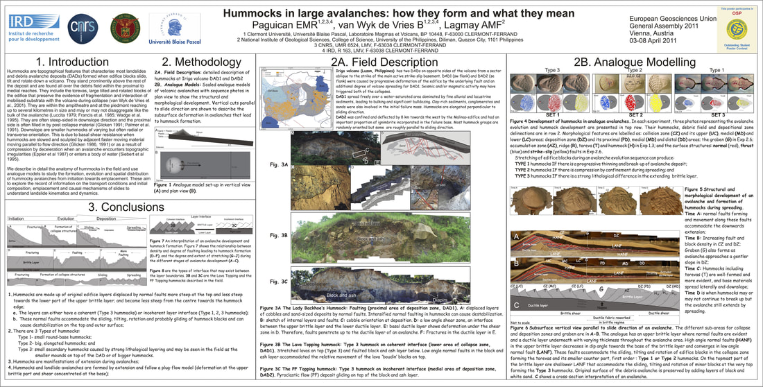
Hummocks are an integral part of most large slope instabilities, whether they be fast emplaced or sluggish. We use analogue modelling, and field characterisation on a number of volcanic and non volcanic large landslides to study the formation of hummocks and explore their importance in understanding landslide kinematics and dynamics. Using beautifully exposed hummock cuts in the Iriga volcano (Philippines) we explore and characterise the internal structure of hummocks from proximal to distal regions and in different lithologies. We compare the information with scaled analogue models. Hummocks initiate from extensional faulting as the landslide begins to form. As motion continues large blocks individualise and move apart creating an initial hummock distribution. Hummock size is a function of position in the initial landslide, that is modified by subsequent hummock break up. Small hummocks are at the front and large ones at the back. Individual hummocks tend to get wider as the avalanche spreads after the initial stages of break up, but decrease in height. The internal structure of a typical hummock is that of normal faults that flatten into low angle detachments at the hummock base, where they merge with the basal landslide shear zone. When landslides become compressive, due to confinement or more gentle slopes, thrusting creates anticlinal hummocks, and in areas of transverse movement hummocks will contain strike-slip flower structures. All these structures together with the models are consistent with a general brittle-slide emplacement model for the studied cases. Where hummocks do not form, nor any fault like feature, a more fluid flow type of emplacement is possible.
Hummocks are an integral part of most large slope instabilities, whether they be fast emplaced or sluggish. We use analogue modelling, and field characterisation on a number of volcanic and non volcanic large landslides to study the formation of hummocks and explore their importance in understanding landslide kinematics and dynamics. Using beautifully exposed hummock cuts in the Iriga volcano (Philippines) we explore and characterise the internal structure of hummocks from proximal to distal regions and in different lithologies. We compare the information with scaled analogue models. Hummocks initiate from extensional faulting as the landslide begins to form. As motion continues large blocks individualise and move apart creating an initial hummock distribution. Hummock size is a function of position in the initial landslide, that is modified by subsequent hummock break up. Small hummocks are at the front and large ones at the back. Individual hummocks tend to get wider as the avalanche spreads after the initial stages of break up, but decrease in height. The internal structure of a typical hummock is that of normal faults that flatten into low angle detachments at the hummock base, where they merge with the basal landslide shear zone. When landslides become compressive, due to confinement or more gentle slopes, thrusting creates anticlinal hummocks, and in areas of transverse movement hummocks will contain strike-slip flower structures. All these structures together with the models are consistent with a general brittle-slide emplacement model for the studied cases. Where hummocks do not form, nor any fault like feature, a more fluid flow type of emplacement is possible.
The development of structures in analogue and natural debris avalanches
Paguican EMR, van Wyk de Vries B, Lagmay AMF, Grosse P
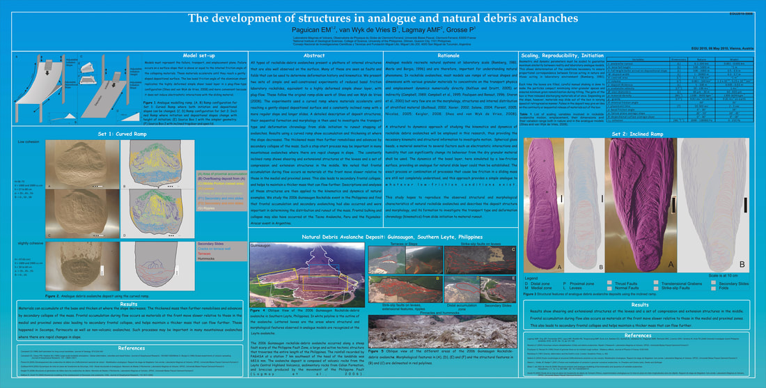
All types of rockslide-debris avalanches present a plethora of internal structures that are also well observed on the surface. Many of these are seen as faults and folds that can be used to determine deformation history and kinematics. We present two sets of simple and well-constrained experiments of reduced basal friction laboratory rockslides, equivalent to a highly deformed simple shear layer, with plug-flow. These follow the original ramp-slide work of Shea and van Wyk de Vries (Geosphere, 2008). The experiments used a curved ramp where materials accelerate until reaching a gently-sloped depositional surface and a constantly inclined ramp with a more regular slope and longer slides. A detailed description of deposit structures, their sequential formation and morphology is then used to investigate the transport type and deformation chronology from slide initiation to runout stopping of avalanches. Results using a curved ramp show accumulation and thickening at where the slope decreases. The thickened mass then further remobilises and advances by secondary collapse of the mass. Such a stop-start process may be important in many mountainous avalanches where there are rapid changes in slope. The constantly inclined ramp shows shearing and extensional structures at the levees and a set of compression and extension structures in the middle. We noted that frontal accumulation during flow occurs as materials at the front move slower relative to those in the medial and proximal zones. This also leads to secondary frontal collapse, and helps to maintain a thicker mass that can flow further. Descriptions and analyses of these structures are then applied to the kinematics and dynamics of natural examples. We study the 2006 Guinsaugon Rockslide event in the Philippines and find that frontal accumulation and secondary avalanching had also occurred and were important in determining the distribution and runout of the mass. Frontal bulking and collapse may also have occurred at the Tacna Avalanche, Peru and the Pajonales-Aracar event in Argentina.
All types of rockslide-debris avalanches present a plethora of internal structures that are also well observed on the surface. Many of these are seen as faults and folds that can be used to determine deformation history and kinematics. We present two sets of simple and well-constrained experiments of reduced basal friction laboratory rockslides, equivalent to a highly deformed simple shear layer, with plug-flow. These follow the original ramp-slide work of Shea and van Wyk de Vries (Geosphere, 2008). The experiments used a curved ramp where materials accelerate until reaching a gently-sloped depositional surface and a constantly inclined ramp with a more regular slope and longer slides. A detailed description of deposit structures, their sequential formation and morphology is then used to investigate the transport type and deformation chronology from slide initiation to runout stopping of avalanches. Results using a curved ramp show accumulation and thickening at where the slope decreases. The thickened mass then further remobilises and advances by secondary collapse of the mass. Such a stop-start process may be important in many mountainous avalanches where there are rapid changes in slope. The constantly inclined ramp shows shearing and extensional structures at the levees and a set of compression and extension structures in the middle. We noted that frontal accumulation during flow occurs as materials at the front move slower relative to those in the medial and proximal zones. This also leads to secondary frontal collapse, and helps to maintain a thicker mass that can flow further. Descriptions and analyses of these structures are then applied to the kinematics and dynamics of natural examples. We study the 2006 Guinsaugon Rockslide event in the Philippines and find that frontal accumulation and secondary avalanching had also occurred and were important in determining the distribution and runout of the mass. Frontal bulking and collapse may also have occurred at the Tacna Avalanche, Peru and the Pajonales-Aracar event in Argentina.
Revisiting the historical debris avalanche deposit at the footslopes of Iriga Volcano, Philippines
Paguican EMR, Lagmay AMF, van Wyk de Vries B, Quina G
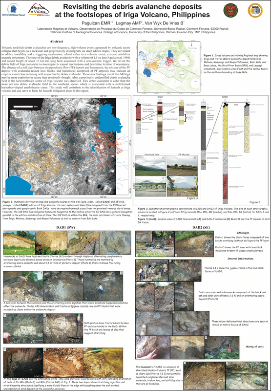
Volcanic rockslide-debris avalanches are low-frequency, high-volume events generated by volcanic sector collapse that begins as a rockslide and progressively disintegrates on steep edifice slopes. They are linked to edifice instability and a triggering mechanism, related either to a volcanic event, extreme rainfall or tectonic movement. The case of the Iriga debris avalanche with a volume of 1.5 cu km (Aguila et al, 1986) and runout length of about 10 km has long been associated with a non-volcanic trigger. We revisit the debris field of Iriga avalanche to investigate its causal mechanisms and determine its time of occurrence. The absence of a soil layer between the pyroclastic flow (PF) deposit and hummocks, the mixture of the PF deposit with avalanche-related lava blocks, and hummocks comprised of PF deposits may indicate an eruptive event close in timing with respect to the debris avalanche. These new findings reveal that Mt Iriga may be more explosive in nature than previously thought. Also, a previously unidentified debris avalanche field in the west-northwest sector of Iriga volcano was identified. This debris avalanche is older than the more obvious debris avalanche field in the southeast sector, which is associated with a well-formed horseshoe-shaped amphitheatre crater. This study will contribute to the identification of hazards at Iriga volcano and can serve as basis for hazards mitigation plans in the region.
Volcanic rockslide-debris avalanches are low-frequency, high-volume events generated by volcanic sector collapse that begins as a rockslide and progressively disintegrates on steep edifice slopes. They are linked to edifice instability and a triggering mechanism, related either to a volcanic event, extreme rainfall or tectonic movement. The case of the Iriga debris avalanche with a volume of 1.5 cu km (Aguila et al, 1986) and runout length of about 10 km has long been associated with a non-volcanic trigger. We revisit the debris field of Iriga avalanche to investigate its causal mechanisms and determine its time of occurrence. The absence of a soil layer between the pyroclastic flow (PF) deposit and hummocks, the mixture of the PF deposit with avalanche-related lava blocks, and hummocks comprised of PF deposits may indicate an eruptive event close in timing with respect to the debris avalanche. These new findings reveal that Mt Iriga may be more explosive in nature than previously thought. Also, a previously unidentified debris avalanche field in the west-northwest sector of Iriga volcano was identified. This debris avalanche is older than the more obvious debris avalanche field in the southeast sector, which is associated with a well-formed horseshoe-shaped amphitheatre crater. This study will contribute to the identification of hazards at Iriga volcano and can serve as basis for hazards mitigation plans in the region.
Extreme Rainfall-Induced Lahars and Breaching of Dikes at Mayon Volcano
Lagmay AMF, Rodolfo R, Tengonciang AMP, Lapus M, Baliatan EG, Rodolfo K, Obille E
On 29–30 November 2006, heavy rains from Supertyphoon Durian remobilized volcanic debris on the southern and eastern slopes of Mount Mayon, generating major lahars that caused severe loss of life and property in downstream communities. The nearby Legaspi City weather station recorded 495.8 mm of rainfall over 1.5 days at rates as high as 47.5 mm/h, far exceeding the initiation threshold for Mayon lahars. For about 18 h, floods and lahars from the intense and prolonged rainfall overtopped river bends, breaching six dikes through which they created new paths, buried downstream communities in thick, widespread deposits, and caused most of the 1,266 fatalities. In order to mitigate damage from future lahars, the deposits were described and analyzed for clues to their generation and impact on structures and people. Post-disaster maps were generated from raw ASTER and SPOT images, using automated density slicing to characterize lahar deposits, flooded areas, croplands, and urbanized areas. Fieldwork was undertaken to check the accuracy of the maps, especially at the edges of the lahar deposits, and to measure the deposit thicknesses. The Durian event was exceptional in terms of rainfall intensity, but the dikes eventually failed because they were designed and built according to flood specifications, not to withstand major lahars.
On 29–30 November 2006, heavy rains from Supertyphoon Durian remobilized volcanic debris on the southern and eastern slopes of Mount Mayon, generating major lahars that caused severe loss of life and property in downstream communities. The nearby Legaspi City weather station recorded 495.8 mm of rainfall over 1.5 days at rates as high as 47.5 mm/h, far exceeding the initiation threshold for Mayon lahars. For about 18 h, floods and lahars from the intense and prolonged rainfall overtopped river bends, breaching six dikes through which they created new paths, buried downstream communities in thick, widespread deposits, and caused most of the 1,266 fatalities. In order to mitigate damage from future lahars, the deposits were described and analyzed for clues to their generation and impact on structures and people. Post-disaster maps were generated from raw ASTER and SPOT images, using automated density slicing to characterize lahar deposits, flooded areas, croplands, and urbanized areas. Fieldwork was undertaken to check the accuracy of the maps, especially at the edges of the lahar deposits, and to measure the deposit thicknesses. The Durian event was exceptional in terms of rainfall intensity, but the dikes eventually failed because they were designed and built according to flood specifications, not to withstand major lahars.
A Geological Perspective to the June 2008 Iloilo Disaster
Paguican EMR, Lagmay AMF
Proudly powered by Weebly
